Learn the Methodology
  1. Knowledge Center
  2. Learn the Methodology

03 Calculate wildfire hazard

Identify wildfire hazard across your analysis area

How our wildfire model works 

To calculate wildfire hazard, Vibrant Planet evaluates burn probability and fire intensity together. These calculations are powered by our Pyrologix, a Vibrant Planet company. Areas with the highest hazard generally contain the greatest combination of burn probability along with fire intensity. 

  • Burn probability (FSim) - the probability that a geographic location (30-m pixel) will experience a wildland fire. Modeled using FSim, which simulates the growth and behavior of hundreds of thousands of fire events, based on historical fire occurrences, weather, terrain, and fuel.
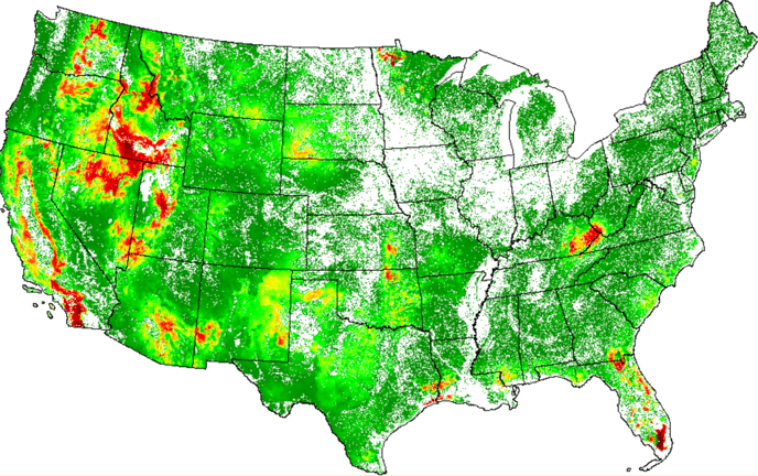
  • Fire intensity (wildEST)- the flame length that the pixel is likely to experience when it burns. This calculation uses a model developed by Pyrologix that performs 200+ simulations and uses local fuel, weather, and topography to generate estimates of contemporary flame lengths within a given pixel.

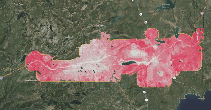
Wildfire hazard mapped in Truckee, California

Wildfire hazard data appears as color-coded polygons over a landscape. The darker the polygon, the higher the hazard. This information feeds into your future risk reduction strategy, helping predict how resources and assets will respond to hazard, and how to help mitigate negative effects. 


Science Corner: A deep dive on FSim and wildEST 


FSim (Fire Simulation): FSim is a sophisticated wildfire simulation system developed by the USDA Forest Service. It employs a spatially explicit Monte Carlo approach to model fire growth across landscapes, incorporating detailed spatial data on fuels, topography, and historical weather patterns. The system simulates thousands of fire seasons, placing random ignitions based on historical ignition density patterns. Each simulated fire grows according to the Minimum Travel Time (MTT) algorithm, which models fire spread based on fuel, weather, and topography. FSim uses a time series of weather data to create artificial weather streams, capturing both daily and seasonal variability. The primary output is a map of burn probability, representing the likelihood of a pixel burning in any given year, along with conditional flame length probabilities. Typically run at 30-m or 90-m resolution, FSim allows for landscape-scale analysis and is widely used in national-level wildfire risk assessments, land management planning, and prioritizing fuel treatment locations.


Fire Intensity (wildEST): WildEST (Wildfire Empirical Spread and inTensity) is a more recent model developed to predict wildfire behavior characteristics. Unlike physics-based models, wildEST is built on statistical relationships derived from observed wildfire data. It considers fuel type, topography (slope, aspect), and weather conditions (wind speed, fuel moisture) to predict several fire behavior characteristics, including rate of spread, flame length, and fireline intensity. Flame length prediction, a key output, serves as a proxy for fire intensity and potential impact. WildEST can be applied at various scales, often matching the 30-m resolution of FSim for integration. One of its strengths is the provision of uncertainty estimates in its predictions, which is valuable for risk assessment. Being empirically based, it's less computationally intensive than physics-based models, allowing for rapid calculations over large areas. WildEST is frequently used to provide fire behavior predictions within the FSim framework, enhancing the overall risk assessment capabilities.

These models, when used in tandem, offer a valuable toolset for understanding both the likelihood and potential severity of wildfires across landscapes.


Next, let’s explore how we help you map resources and assets of value, so you can ultimately understand the opportunities to reduce risk to the things that matter most.